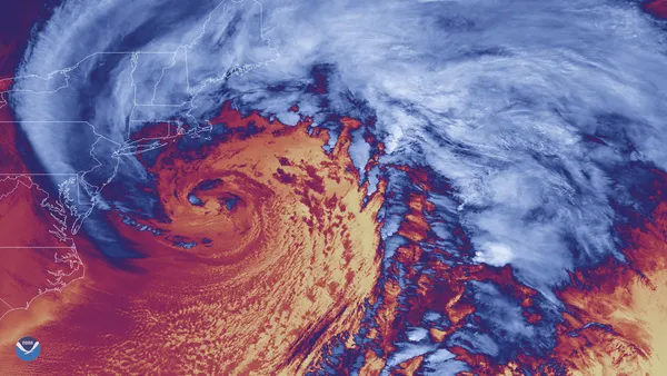
Bomb cyclone expected offshore this weekend, bringing wind, cold, and limited snow chances to Maryland

What is forecast to happen near Maryland
A rapidly intensifying coastal storm — commonly described as a “bomb cyclone” when its central pressure drops quickly — is expected to strengthen offshore of the Mid-Atlantic during the weekend of Jan. 31–Feb. 1, 2026. While the most disruptive snowfall is projected to remain closer to the storm’s core and east of the Interstate 95 corridor, the system is forecast to amplify dangerous cold and bring strong winds across Maryland.
In central Maryland, including the Baltimore region, current projections indicate the primary impacts are likely to be wind and wind-driven cold rather than a heavy, widespread snow event. However, forecasters continue to monitor the storm track because small shifts can sharply change the western edge of snowfall.
Timing: strongest winds and cold, with a narrow window for light snow
Friday, Jan. 30: Cold conditions remain in place ahead of the coastal storm’s peak.
Saturday night into early Sunday (Jan. 31–Feb. 1): A brief period of light snow or flurries is possible in parts of Maryland as the storm deepens offshore. The higher-probability impacts are increasing winds and sharply lower wind chills.
Sunday, Feb. 1: Gusty winds are expected to continue, with the cold likely to remain the dominant hazard even where little or no snow falls.
Snow potential: higher at the coast, lower inland
Maryland’s coastline and the Lower Eastern Shore are positioned closer to the storm’s favored snow banding and could see more meaningful accumulation than inland communities if the storm remains offshore. By contrast, Baltimore and areas along I-95 appear more likely to sit near the precipitation cutoff, where outcomes range from little accumulation to minor totals depending on the exact track.
Because the cutoff is typically sharp in offshore storms, the difference between a minimal event and a plowable snowfall can hinge on whether the low-pressure center shifts modestly westward or stays farther out to sea.
Wind and cold: the most consistent signal for Maryland
Forecast guidance shows a high likelihood of strong, gusty winds across much of the state, with higher gust potential nearer the water. The wind will also worsen already frigid conditions, creating dangerously low wind chills. Those conditions can increase the risk of frostbite with prolonged exposure and can complicate travel and outdoor work even without significant snowfall.
Why this weekend’s storm is being watched closely
Offshore winter storms can produce a steep “snowfall cliff,” where totals drop off quickly inland even as heavy snow falls near the coast.
Maryland has already faced notable winter impacts this month, including heavy snow and ice in the Baltimore area during the Jan. 22–26 period. With cold air entrenched, any additional snow or ice that falls this weekend could be slow to melt and may contribute to lingering slick spots.
What to monitor next
Whether the storm track shifts closer to the coast, which would raise snow potential westward toward the Chesapeake Bay.
The onset and duration of strongest wind gusts, particularly in coastal communities.
Any winter weather advisories or warnings issued as confidence increases closer to Saturday.
Forecast details are expected to sharpen as the storm approaches, with the most meaningful adjustments often occurring within 24–48 hours of onset.